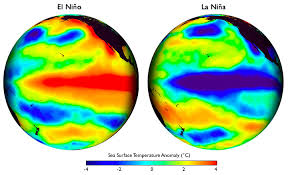
A key location on the Pacific Ocean is far hotter than the highest temperature recorded during the 1997 El Nino.
El Nino this year could be among the most powerful on record, scientists say, which would be even higher than the 1997 El Nino record.
“This thing is still growing and it’s definitely warmer than it was in 1997,” said Bill Patzert, climatologist with NASA’s Jet Propulsion Laboratory in La Cañada Flintridge.
In terms of temperature, scientists claim that the readings of this year have bypassed the previous record of the 1997 El Niño.
The temperature reading was described as significant by Daniel Swain, a climate scientist at Stanford University.
“In the key region of the Pacific Ocean west of Peru, it is the highest such weekly temperature above the average in 25 years of modern record keeping,” Stamford said.
A Southern California National Weather Service office stated Wednesday that the ongoing El Niño could be in the top three strongest events on record, and possibly the strongest ever.
Compared to other strong events that have occurred since 1950, the latest readings for warm Pacific Ocean temperatures put the current El Niño, which began in March have been marked as the second-strongest.
Warning Coordination Meteorologist Eric Boldt said in a briefing video posted Wednesday that the “sea-surface anomaly” for those ocean temperatures in early November was the greatest such anomaly recorded in 65 years.
“This could be the strongest El Niño ever recorded,” the weather service’s Los Angeles/Oxnard office warned on Facebook in announcing Boldt’s briefing.
In keeping with forecaster consensus as described by the weather service’s Climate Prediction Center earlier this month, the current phenomenon could rank among the top three strongest events since 1950, Boldt said.
Bolt added that while downtown Los Angeles typically gets around 15 inches of rain per year, there has been in above-normal rainfall in the area in the past six months due to a strong El Nino, Boldt said.
In 1982-1983, more than 33 inches of rain fell on L.A., according to Boldt while there was more than 30 inches of rain in 1997-98.
This year downtown L.A. has received more rain than it had in total from 2011 to 2015, a period that marked the four driest years in 138 years of record-keeping.
Bolt added that Southern Californians should be prepare for coastal flooding and damage, as well as flash flooding.
“Widespread flooding is more likely when the region becomes saturated after several storms in a row, and little break between systems,” Boldt said.
The storms are expected to peak in January through March.
“One El Niño winter will not end the drought,” Boldt said.
(Source:www. ktla.com)


